← Maritime Note | Home About Management Note
🚢 Maritime Radiocommunications · GMDSS Guide

Maritime Radiocommunications and GMDSS Guide

Ship radiocommunication equipment is more than a way to talk. Its real value is making sure distress alerts, safety information, search-and-rescue coordination, positioning, and bridge-to-bridge communication still work when a ship is in trouble.

Topics covered in this note

GMDSS Sea Areas A1 · A2 · A3 · A4
Main Equipment Groups Alerting · Satellite · MSI · EPIRB · SART
SOLAS Functional Requirements Nine radiocommunication functions and survey logic
01 · Big Picture

Start with three questions: why do ships need this equipment?

For readers who are not familiar with maritime operations, GMDSS, DSC, EPIRB, and SART can quickly become a wall of acronyms. A better starting point is to understand the safety problem each device is meant to solve.

Chapter guide: This section builds the big picture first: instead of memorising acronyms, understand which safety problem each type of equipment solves.
🆘

1. When a ship is in distress, who will know?

DSC, satellite ship earth stations, and EPIRB mainly handle distress alerting. They help shore-based rescue centres and nearby ships quickly identify which ship is in distress, where it is, and what help may be needed.

DSC Satellite EPIRB
🌐

2. How does a ship receive safety information at sea?

MSI systems receive navigational warnings, weather forecasts, and safety messages. NAVTEX is common near coasts, EGC is used offshore via satellite, and HF NBDP may be needed for long-range or A4-area coverage.

MSI NAVTEX EGC
📍

3. How do rescuers find people?

EPIRB provides distress position information, while SART or AIS-SART helps rescuers locate survival craft or people once they are near the scene. The former sends the distress position; the latter supports final on-scene locating.

COSPAS-SARSAT Radar SART AIS-SART
The purpose of ship radiocommunication equipment is not to add more machines on board. It is to ensure that a ship can alert, be located, receive safety information, and coordinate search and rescue with shore authorities and nearby vessels during an emergency.
Equipment category Plain-language function Typical equipment What to remember
Distress alerting Send the distress signal out DSC, satellite ship station, EPIRB The point is to quickly notify shore rescue units and nearby ships.
Safety information reception Receive navigational and weather warnings NAVTEX, EGC, HF NBDP The farther a ship sails from shore, the less it can rely only on coastal systems.
Search-and-rescue locating Help rescuers find the scene Radar SART, AIS-SART SART is used for more precise locating once rescuers are near the scene.
Navigation and security monitoring Identify, track, record, and report security alerts AIS, SSAS, LRIT, VDR They are usually not GMDSS equipment, but they are still important SOLAS equipment.
02 · Sea Areas

GMDSS sea areas: not geographic labels, but communication coverage

The difference between A1 and A4 is not simply a line on a chart. It is about which coast stations, satellites, and radio bands a ship can rely on for distress communication.

Chapter guide: Sea areas are not just geographic zones. They are defined by coast-station and satellite communication coverage, which then drives the equipment needed on board.
Sea area Simple explanation Main communication capability Equipment logic
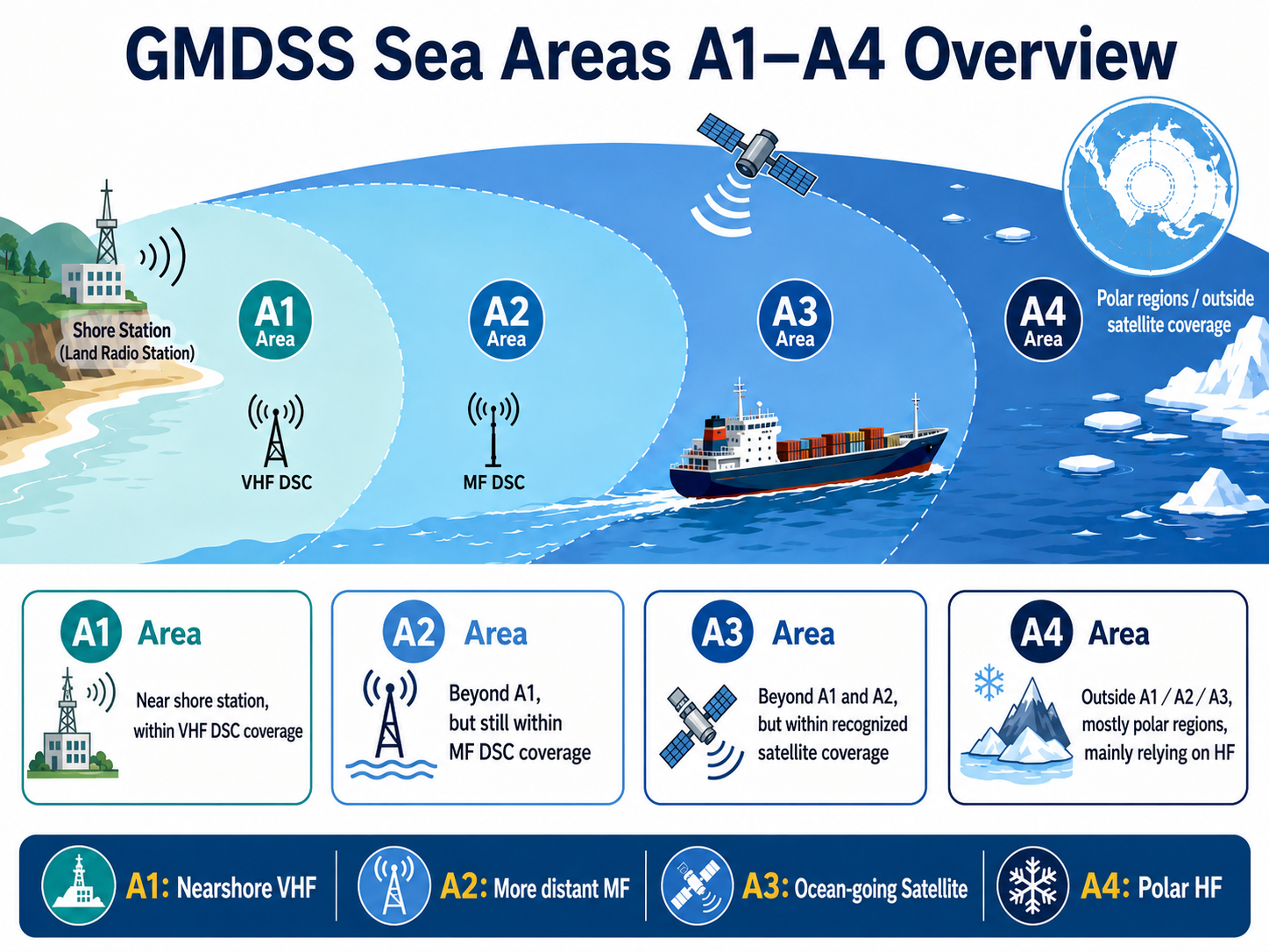
A1 Near coast stations, covered by continuous VHF DSC watchkeeping VHF Nearshore area, but still requires distress alerting, MSI, EPIRB, and search-and-rescue locating equipment.
A2 Beyond A1, but still within MF DSC coast-station coverage MF + VHF Farther than A1, so MF communication capability is added.
A3 Beyond A1/A2, but within recognised satellite service coverage Satellite + MF + VHF For ocean passages, the key is satellite ship station capability and long-range safety information reception.
A4 Outside A1, A2, and A3, often related to polar regions or satellite coverage limits HF + MF + VHF Traditional satellite coverage alone may not be enough; HF communication becomes important.
🧭

Memory aid

A1 relies on VHF, A2 adds MF, A3 relies on satellite service, and A4 requires attention to HF. The farther from coast-station coverage, the more complete the equipment requirements usually become; high-latitude or special areas require particular attention to satellite coverage and HF communication.

🛰️

Concept to note after 2024

Actual A3 coverage depends on the recognised satellite service installed on board. For example, traditional Inmarsat and Iridium have different coverage characteristics; Iridium can provide global coverage including polar regions.

03 · Equipment Atlas

Main GMDSS Equipment Map: What does each device do?

This is not a complete regulatory checklist. It is a function-based way to understand the equipment quickly. This reading order works well for public sharing because readers can first grasp each device's role, then return to carriage requirements.

Chapter guide: This chapter groups GMDSS equipment by function: distress alerting, safety information reception, long-range communication, distress position reporting, and search-and-rescue locating.
DSC
Distress Alert

Digital Selective Calling

DSC allows ships to receive or send distress alerts automatically, rather than relying only on a person continuously listening to a voice channel.

  • Can send ship-to-shore and ship-to-ship alerts
  • Distress alerts may include position, identity, and nature of distress
  • Used with VHF, MF, and HF for different ranges
VHF / MF / HF
Radio

Radio communication on different bands

VHF suits short-range communication, MF covers farther sea areas, and HF is used for long-range or A4-type areas.

  • VHF: common for nearshore and ship-to-ship communication
  • MF: important capability for A2 sea areas
  • HF: important backup for long-range and polar-area communication
Satellite
Ocean Area

Recognised mobile satellite services

Used for ocean-area communication and distress alerting. Common systems include Inmarsat, Iridium, and BeiDou.

  • Inmarsat: traditional maritime satellite communication system
  • Iridium: covers polar regions and suits high-latitude operations
  • BeiDou: a recognised system, but coverage area must be checked
MSI
Safety Info

Maritime Safety Information

MSI includes navigational warnings, weather forecasts, safety messages, and related updates. It keeps ships informed of risks while underway.

  • NAVTEX: common in coastal areas, 518 kHz
  • EGC: received via satellite for ocean areas
  • HF NBDP: used for A4 or specific areas
EPIRB
Beacon

Emergency Position-Indicating Radio Beacon

When a ship is in distress or sinks, EPIRB can be activated automatically or manually and transmit ship identity and position through satellite systems.

  • Usually routed through the COSPAS-SARSAT system
  • Ship name, identity codes, and flag information must be correctly registered
  • Must not be tied to the ship; it must be able to float free
SART
Locate

Search-and-rescue locating equipment

SART is used to locate survival craft or the distress scene after rescuers are nearby. It may be Radar SART or AIS-SART.

  • Radar SART: produces a distinctive response on radar
  • AIS-SART: lets nearby AIS equipment see the locating signal
  • Its role is final on-scene locating, not replacing distress alerting
⚠️

Especially important: EPIRB must not be tied down

EPIRB is designed to send a distress beacon automatically or manually when a ship sinks or is in distress. If it is secured to the ship by a lanyard, tie, or other restraint, it may not float free when the vessel sinks, defeating one of its most important lifesaving functions.

How EPIRB Works

How does an EPIRB distress signal reach the rescue centre?

1

Activation

The EPIRB is activated manually or automatically and starts transmitting a distress signal.

2

Satellite reception

COSPAS-SARSAT satellites receive the 406 MHz beacon.

3

Data forwarding

The system forwards ship identity and position data.

4

Rescue coordination centre

The MRCC decodes the message and assesses the position.

5

Search and rescue starts

Nearby ships, coast stations, aircraft, and maritime rescue units are coordinated.

04 · Non-GMDSS Equipment

Not GMDSS, but still key equipment for ship safety and security

AIS, SSAS, LRIT, and VDR are often discussed alongside radio or navigation equipment, but they are not core GMDSS equipment under SOLAS Chapter IV. Understanding this helps avoid mixing up distress communication, navigational safety, security alerting, and accident data recording.

Chapter guide: These systems are not core GMDSS equipment under SOLAS Chapter IV, but they remain highly relevant to navigational safety, security, and accident investigation.
Equipment Name Main purpose Difference from GMDSS
AIS Automatic Identification System Exchange ship identity, position, course, speed, and collision-avoidance information Focused on navigational safety, not a distress alerting system.
SSAS Ship Security Alert System Covertly notify shore authorities during a security threat Does not broadcast a public distress call to nearby ships and should not create audible or visual alarms on board.
LRIT Long-Range Identification and Tracking Allows governments or authorised authorities to track ships at long range Not a broadcast system and not used by nearby ships for real-time collision avoidance.
VDR / S-VDR Voyage Data Recorder Records navigation, operation, and accident-investigation data Functions like a ship's black box; its focus is post-accident reconstruction, not distress communication.
AIS is visible nearby; LRIT is long-range government tracking; SSAS is a covert security alert; VDR preserves data for accident investigation.
05 · Regulatory Logic

Regulations do not only ask whether equipment is installed; they ask whether it will really work in distress

The core of GMDSS is not a list of equipment. It is functional requirements, independent backup, maintenance arrangements, operator qualifications, and test records. This is the mindset to keep during surveys.

Chapter guide: Regulations are concerned not only with whether equipment is installed, but whether the nine communication functions can be reliably fulfilled during distress.
📜

Main regulatory sources

Maritime radiocommunications are mainly governed by two systems: the ITU Radio Regulations cover frequencies, ship stations, operator qualifications, and documents; SOLAS Chapter IV covers GMDSS and ship radio equipment requirements.

🧑‍✈️

Ships covered

Passenger ships on international voyages are covered regardless of tonnage; cargo ships on international voyages are generally covered from 300 GT upward. Domestic or smaller ships depend on flag-state requirements.

Nine functional requirements: what GMDSS must achieve

The nine functions can be understood as a complete safety communication chain: alerting, receiving, coordination, on-scene communication, locating, safety information, and general communication.

1

Ship-to-shore distress alerting

A ship in distress can notify shore-based rescue units.

2

Shore-to-ship distress alerting

The ship can receive distress-related alerts from shore.

3

Ship-to-ship distress alerting

Nearby ships can become aware of a distress situation.

4

Search-and-rescue coordinating communication

Supports coordination among rescue centres, coast stations, and ships.

5

On-scene communication

Keeps communication at the scene between the distressed ship and rescue units.

6

Locating signals

Helps rescue units find the distressed ship or survival craft.

7

Receiving MSI

Receives navigational warnings, weather information, and safety messages.

8

General radiocommunications

Allows general communication with shore radio systems or networks.

9

Bridge-to-bridge communication

Ships can communicate directly for navigational safety.

🔁

Key survey logic: at least two separate and independent means of distress alerting

A ship should not leave port unless it can transmit ship-to-shore distress alerts by at least two separate and independent radiocommunication systems. This is not about buying two identical units; it is about avoiding single-technology or single-system failure.

Three ways to maintain equipment availability

🏢

Shore-based maintenance

Supported by qualified shore-based service providers and common in merchant shipping. The focus is service coverage, repair arrangements, and documentary evidence.

🧰

At-sea electronic maintenance

The ship must have qualified personnel, tools, test equipment, technical documents, and spares. This is not just a crew member restarting equipment.

📡

Duplication of equipment

Necessary duplicate equipment is fitted according to sea area, with independent antennas and immediate availability as applicable.

Sea area Equipment availability concept Practical reading
A1 / A2 At least one of the three methods The operating range is closer to shore, but the ship still needs to show that equipment can remain available.
A3 / A4 At least two of the three methods Ocean or special-area operations carry higher risk, so maintenance and backup requirements are stricter.
06 · Carriage Logic

A quick way to read carriage requirements: the farther the ship goes, the more complete its communication capability must be

The complete carriage requirements for a ship must still be checked against SOLAS, flag-state, and class requirements. As a quick reading, however, the following progression explains the logic.

Chapter guide: Carriage requirements can be understood in one sentence: the farther a ship sails, the more complete its communication and backup capability must be.
Illustration of GMDSS sea areas A1 to A4, expanding from nearshore VHF coverage to MF, satellite, and HF communication ranges
GMDSS sea areas are defined by coast-station and satellite communication coverage, not simply by geographic lines. A1 relies on VHF, A2 adds MF, A3 relies on satellite service, and A4 requires HF and attention to polar or other special coverage limits.
Sea area Main added capability Quick View
A1 VHF radio + VHF DSC + MSI + EPIRB + survival craft equipment Nearshore does not mean low risk; distress alerting, MSI, and search-and-rescue locating capability are still required.
A1 + A2 Add MF radio / MF DSC Once beyond nearshore VHF range, MF becomes the main added communication capability.
A1 + A2 + A3 Add satellite ship station For ocean passages, reliable satellite communication and EGC reception are key.
A1 + A2 + A3 + A4 Add MF/HF radio + MF/HF DSC In A4 or areas outside satellite coverage, HF is an important communication method.
📻

Number of two-way VHF radios for survival craft

Cargo ships of 300-499 GT usually need 2 units; cargo ships of 500 GT and above and all passenger ships usually need 3 units. These are used for communication between survival craft and rescue units after abandonment.

📍

Number of search-and-rescue locating devices

Cargo ships of 300-499 GT usually need 1 unit; cargo ships of 500 GT and above and all passenger ships usually need 2 units. These may be Radar SART or AIS-SART.

07 · Survey & Deficiencies

Survey focus: the most common problem is often not missing equipment, but unreliable equipment

Common radio survey deficiencies often involve power supply, antennas, position data, identity settings, records, and crew familiarity. These may look minor, but they can directly affect the success of distress communication.

Chapter guide: In survey practice, the problem is often not a total absence of equipment, but unreliable settings, power supply, certificates, records, or maintenance condition.
🔋

Power supply and batteries

Expired batteries, insufficient capacity, charger faults, or backup power that does not supply displays or printers are common deficiencies. GMDSS equipment must still work when main power fails.

📡

Antennas and connectors

Many communication problems are not caused by failed main units, but by broken antennas, corroded connectors, poor insulation, blocked satellite antennas, or outdated antenna layout drawings.

🛰️

Position and time data

If a distress alert does not include correct GNSS position and time data, the rescue centre may not be able to assess the distress location accurately. Automatic position input must update reliably.

🪪

Identity data

Incorrect MMSI, call sign, ship name, flag code, or EPIRB registration data can make distress information inconsistent with the actual ship.

📘

Documents and records

Radio logs, annual tests, five-year shore-based maintenance, battery capacity tests, and service certificates are important evidence that equipment remains available.

🧑‍✈️

Crew familiarity

Equipment being on board does not mean it can be operated correctly. Crew should be familiar with test calls, distress procedures, cancelling false alerts, and basic fault recognition.

Testing and records: making availability evidence-based

Daily

Basic condition checks

Printer condition, DSC internal tests, radio battery status, and similar checks.

Weekly

Communication capability tests

MF/HF DSC test calls, main and backup VHF equipment tests, reserve energy tests, and similar checks.

Monthly

Survival craft and locating equipment checks

EPIRB self-tests, SART checks, survival craft two-way VHF, battery and antenna checks, and similar items.

Annual

EPIRB annual test

406 MHz EPIRB annual test and related certificates.

Every five years

EPIRB Shore-based maintenance

Usually aligned with battery replacement and shore-based maintenance certification.

A useful survey summary sentence

The point of a radio survey is not only to confirm that equipment exists on board. It is to confirm that it is in the right place, powered correctly, configured with correct identity and position data, understood by the crew, and supported by test and maintenance records showing that it can actually work in distress.

08 · Final Takeaway

Final takeaway in one sentence

Chapter guide: The final section condenses the note into a few points that are easy to share, review, and use for further discussion.
The value of GMDSS is not in the equipment names themselves, but in building a reliable communication architecture that can still provide distress alerting, safety information reception, search-and-rescue coordination, and locating across different sea areas and failure scenarios.
🆘

For general readers

Remember this: the purpose of this equipment is to make a ship visible, audible, and findable when something goes wrong.

⚙️

For readers with some maritime background

Remember this: the regulatory focus is on functions, redundancy, maintenance, operator qualifications, and records, not just an equipment list.

🔍

For survey practice

Remember this: the most common weak points are often batteries, antennas, positioning, identity data, service certificates, and crew familiarity.